
Is it just a storm or is it climate change?
In the future, to assess with certainty whether a storm or hurricane is an extreme event or is rather to be considered normal, the Helmholtz-Zentrum Geesthacht has now created the “Storm Monitor” website www.storm-monitor.eu. Those interested can use it to compare the current situation with storm trends of the past seven decades. The website is equally aimed at the interested public, the media and government bodies.

Photo: Unsplash/Dembee Tsogoo
Computer calculations predict that climate change could lead to an increase in extreme weather events in the future—such as storms in coastal regions. Of course, there have always been severe storms. Now, however, many people often ask themselves if a severe storm is due to climate change. The Helmholtz-Zentrum Geesthacht’s (HZG) “Storm Monitor” website www.storm-monitor.eu, which has just gone online, will provide an answer to this question in the future. The Storm Monitor compares the current storm situation with wind data from the past seven decades, which makes it possible for the first time to answer questions at a glance, such as: “Is this current storm still considered normal or is this climate change?” This can now be answered in near real time after the event.
Is this a particularly stormy season?
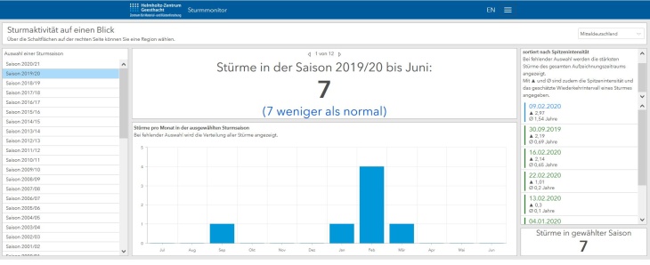
Various aspects can be selected in the storm monitor dashboard. On this screenshot you can see that in the 2019/2020 season 7 storms occurred in the region of Central Germany. The monitor shows that this is 7 storms less than the long-term average of 14 storms per season. This means that the number of storms is significantly lower than in the past years. Screenshot: storm-monitor.eu
The Storm Monitor provides various storm information in well-organized graphics. Website visitors can, for example, see how many storm events took place in the current season or in the past month and to what extent that number deviates from the long-term trend, whether the number is lower or higher. With regard to climate change, it should be of particular interest to many people that the past years were by no means the stormiest. The storm intensity in the 1980s and the early 1990s was considerably higher than today. Those interested can also find information on the most severe storms in northern Germany in the past seven decades. The current storm situation is compared to the past as well. The most severe storm event, “Adolph Bermpohl”, occurred in 1967 and was named after the rescue cruiser of the same name of the Deutsche Gesellschaft zur Rettung Schiffbrüchiger (DGzRS), which was involved in a serious accident at the time. Such high wind speeds have never again been measured across the German Bight since then. Compared to this catastrophic event, the storm situation over the past few years, as shown clearly by the storm monitor, has been rather moderate.
Information for everyone
The Storm Monitor is now aimed at journalists and all those interested in the weather, particularly in storms. In addition, the 70-year-long time series will be made publicly available in the future so that insurance companies or government authorities responsible for the safety of the population or for disaster control can also use the Storm Monitor.
HZG method used as basis for the Storm Monitor

Der Meteorologe Dr. Oliver Krüger beschäftigt sich am HZG mit Windgeschwindigkeiten und Stürmen. Foto: HZG/Gesa Seidel
“The Storm Monitor is based on a method for calculating storm activity that was developed by the German Weather Service and in Geesthacht in the 1990s,” says the meteorologist Dr Oliver Krüger, who designed and implemented the Storm Monitor together with his master student Daniel Krieger. Normally, the weather services measure the wind velocity at ten metres height above the ground, Krüger points out. If, however, you want to compare the storm events in a region over many decades or reconstruct past storm activity, ground level measurements at ten metres height are unsuitable because they fluctuate too much. One reason for this is that the surroundings can falsify the measurement of the actual wind speed. For example, houses or hills change the air flow near the ground. Over the course of decades, trees and forests grow, which over time can also lead to deviating measurement results. Measurement technology has also changed over the years, leading to additional deviations.
Reliable air pressure values from the last seventy years
Oliver Krüger and Daniel Krieger have therefore used different data for the seventy-year time period. The foundation was the much more reliable air pressure values from which they calculated the wind. Air pressure differences result in air movements. Depending on how large the air pressure difference is, the airflow—that is the wind—is stronger or weaker. The two researchers have calculated in detail the wind that blows in an altitude of several kilometres: the geostrophic wind. It is not influenced by the structures close to the ground and is therefore a reliable parameter over time. Studies have shown that the wind close to the ground and the geostrophic wind are closely related. Therefore, statements about the behaviour of the wind near the ground and also about storm activity can be derived from the behaviour of the geostrophic wind.
Storms and storm surges
The Storm Monitor is based on the idea of the Storm Surge Monitor, which has also been developed by the HZG’s Institute of Coastal Research and has been operated by the HZG for some time now. The Storm Surge Monitor is updated daily and uses the water level measurements on the German North Sea and Baltic Sea coasts that are collected by the responsible government authorities and that are made available on Pegelonline. These measurements are automatically analysed daily and put in relation to long-term storm surge statistics. Using the example of six tide gauges on the German North Sea coast (Husum, Helgoland, Cuxhaven, Hamburg [St. Pauli], Bremen [Weserwehr] and Norderney) and four Baltic Sea gauges (Flensburg, Kiel [Holtenau], Travemünde and Warnemünde), current storm surges are continuously compared to the storm surge events of recent decades.
Further information
- Storm Monitor Website www.storm-monitor.eu
- “Correctly classifying the strength of a storm” Interview with Dr. Oliver Krüger about the Storm Monitor
- Helmholtz Climate Initiative Website of the Climate Initiative
- Storm Surge Monitor Website Storm Surge Monitor
Contact
Institute of Coastal Research
Phone: +49 (0)4152 87-1559
E-mail contactWebsite
Helmholtz-Zentrum Geesthacht
Helmholtz-Zentrum Geesthacht
Phone: +49 (0) 41 52 / 87 - 1784
E-mail contact