
Special Award for ‘Digital Earth’ at the ‘Digital Leader Awards’
Last night, the Helmholtz project ‘Digital Earth’ for Integrated Earth Science Research was awarded a special first time prize for ‘Digital Science’ at the ‘Digital Leader Awards’ in the category ‘Society’. The companies NTT and IDG Business Media, together with other business partners, awarded prizes across all kinds of sectors to projects and teams that drive the digital transformation. The finalists in 2020 included corporations such as Infineon, BMW and the Ergo Group, as well as public authorities such as the Federal Employment Agency. However, the Helmholtz project is the first winner from publicly funded research.
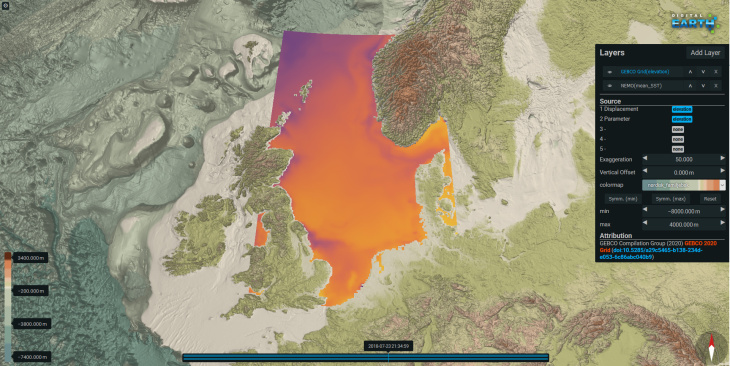
Der Screenshot aus dem Digital Earth Viewer: Damit können Simulations- und Messdaten geographisch und zeitlich interaktiv exploriert und verglichen werden. Bild: Digital Earth
Last night was indeed thrilling for the Helmholtz ‘Digital Earth’ team. It was one of the nominees for the renowned ‘Digital Leader Awards’, presented to pioneers of the digital transformation. Shortly before the end of the award ceremony, the moderation team declared ‘Digital Earth’ the winner of a special award for ‘Digital Science’ in the category ‘Society’.
‘This is incredibly great. We are the first project from the field of publicly funded research that received an award and they were so fascinated about what we are doing that they created a special award,’ says Prof. Dr. Jens Greinert from the GEOMAR Helmholtz Centre for Ocean Research in Kiel. Professor Greinert is the coordinator of ‘Digital Earth’, which consists of eight Helmholtz centres working in cooperation together. The centres consist of GEOMAR, the Alfred Wegener Institute Helmholtz Centre for Polar and Marine Research (AWI), the Helmholtz Centre Potsdam - German Research Centre for Geosciences (GFZ), Forschungszentrum Jülich (FZJ), the Helmholtz Centre München (HMGU), the Helmholtz Zentrum Geesthacht Centre for Materials and Coastal Research (HZG), the Karlsruhe Institute of Technology (KIT) and the Helmholtz Centre for Environmental Research (UFZ).
‘Digital Earth’, which launched in May 2018, is part of a broad strategy of the Helmholtz Association in the ‘Earth and Environment’ research field. It aims to integrate the eight centres more closely in terms of infrastructure, data technology and data-driven science. Scientists collect atmospheric, marine and terrestrial data using sensors in the field and satellites in space, which is analysed in laboratories and modelled on high performance computers. However, integrating the large and particularly heterogeneous data from many different sources is difficult and needs a new approach to scientific working. ‘We are developing new methods to merge data from atmospheric, marine and terrestrial research and analyse them jointly in an efficient way across Earth compartments and natural science disciplines,’ says Professor Greinert, describing the project's goals.
The researchers in ‘Digital Earth’ are not only using new data science methods, such as machine learning and analysis workflows, but they are also improving them. ‘Close and integrated cooperation between natural and data scientists is necessary to better understand the complex processes in the Earth system and to be able to provide answers to the challenges of climate change, resource security and increasing environmental hazards,’ emphasises Professor Greinert.
The jury of the ‘Digital Leader Award’ also highlighted the great importance of digital sciences for the continued development of the Earth Sciences, even if one cannot yet measure results in terms of numbers or profits, as is the case with other award winners.
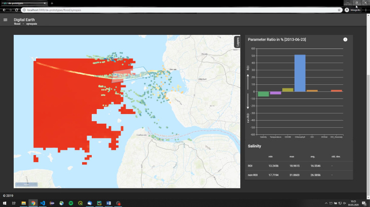
The screenshot shows the "Flood Explorer", a jointly developed tool in the Digital Earth project. Picture: HZG
Climate researcher Diana Rechid (GERICS): "In the project, we are developing an instrument that makes it much easier to access simulated precipitation data. Standardized approaches will support the predictive detection of floods in a region and also take into account the long-term development of such extreme events under climate change".
"What is special about Digital Earth is the large number of different disciplines that have to come together to jointly develop results such as the "Flood Explorer" or other standardized approaches. We all learned a lot and it was fun," adds HZG coastal researcher Holger Brix.
Background information: HZG in Digital Earth
Two examples are given to test the methods of data analysis and cross-disciplinary cooperation: On the one hand, the researchers will deal with floods and their effects, and on the other hand they will work on an overview of methane sources in the German Bight.
At the Institute of Coastal Research scientists contribute to both parts: In the case of the flood example, they combine data from a variety of sources, such as FerryBoxes and model data, to gain a more comprehensive picture of the extent and effects of the pollutants and nutrients that are washed into the North Sea during a flood on the Elbe. In the methane example, coastal researchers are working to use chemical transport models and data from measurement campaigns to identify both man-made and natural sources of the greenhouse gas methane in the German Bight and to better understand their interaction with the atmosphere.
Contact:
Helmholtz-Zentrum Geesthacht